Commercial and industrial Drone Applications.
*
Commercial and industrial Drone Applications. *
Explore our Drone Solutions for your Business.
-
![]()
Hyperspectral Drone Imagery.
Hyperspectral drone imagery is a cutting-edge technology that utilises drones equipped with advanced sensors to capture data across various wavelengths of light. Unlike conventional imaging that relies on the visible spectrum, hyperspectral imaging provides a wealth of information across hundreds of spectral bands. This allows for a more detailed analysis of material properties and conditions, making it an invaluable tool across numerous industries.
Applications
Agriculture: Hyperspectral imaging can assess crop health, identify pest infestations, and optimise fertilisation strategies by analysing plant stress levels and nutrient content. This enables precise agricultural practices, ultimately leading to improved yield and resource management.
Environmental Monitoring: It plays a crucial role in detecting changes in land cover, monitoring water quality, and assessing the impact of environmental changes. The ability to identify specific material signatures empowers researchers to track ecological shifts and adhere to conservation efforts.
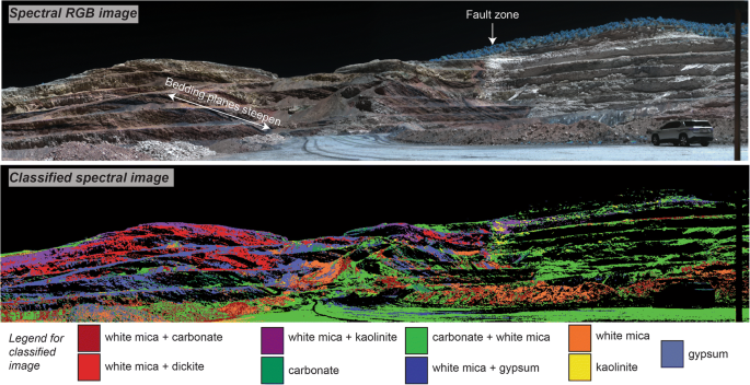
Mining and Minerals Exploration: In the mining sector, hyperspectral imagery aids in identifying mineral compositions and mapping geological features. This technology enhances exploration efficiency and reduces operational costs by pinpointing areas of interest more accurately.
Infrastructure Inspection: Drones equipped with hyperspectral sensors can inspect infrastructure such as roads, bridges and powerlines.
-
![]()
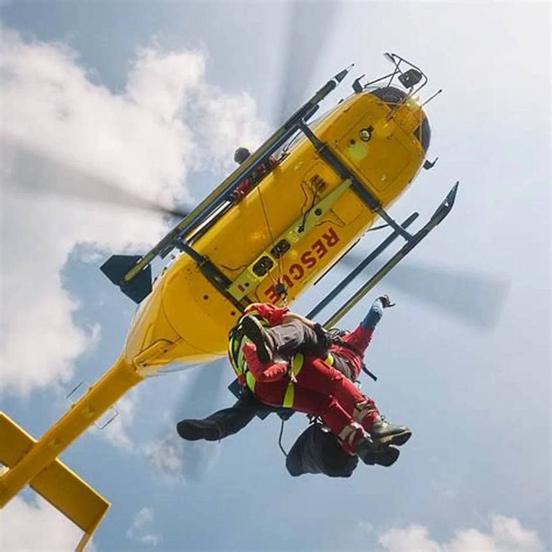
Trackz Lifeseeker Search and Rescue
In the realm of drone search and rescue, every mission begins with a vision — a commitment to save lives through innovative technology. At Lifeseeker, we understand that every second counts, and that’s why our drones are equipped with advanced imaging and tracking technologies designed for precision and reliability in emergencies. By harnessing the power of drone hyperspectral imaging, we provide solutions that can efficiently cover extensive search areas, identifying missing persons or surveying disaster-impacted zones with unparalleled accuracy.
The right solution for your SAR missions
Lifeseeker is based on a simple premise: the cell phone is the world’s most widespread beacon. Mobile communications technologies have had a huge social impact in recent years and almost everyone owns a cell phone. Lifeseeker takes advantage of this and turns these widely used devices into emergency beacons capable of guiding rescue teams to an exact location.Real Missions Saving Lives
This system allows rescue teams to communicate with the missing person (without the need for them to do anything) during search and rescue operations. This way, rescue teams will have quick access to information vital to the success of the mission, such as the victim’s condition or whether there is any type of medical need.Accurate geolocation
Lifeseeker is an aeronautical mission system for Search and Rescue, capable of accurately locating missing persons through their mobile phones – even in areas without coverage and with unfavorable weather conditions. It can be used both in manned vehicles (fixed wings and helicopters) and in unmanned vehicles (UAVs / drones). This device turns mobile phones into emergency beacons that allow search and rescue teams to quickly guide them to the exact location of the missing person. Lifeseeker optimizes those missions in which every second counts to efficiently locate the affected person, making a difference in each mission.Optimizing SAR missions
Lifeseeker is an aeronautical mission system for UAVs/drones, helicopters and fixed-wing aircraft, which is making a big difference by helping search and rescue teams in any type of operation. This technology allows search and rescue missions to be carried out even in situations with low or no visibility, including night flights. Lifeseeker helps reduce tracking time during SAR operations and requires less human resources, optimizing operational costs. In addition, the system can be integrated into the main Mission Management Systems (MMS). -
![]()
Drone Mining Solutions.
Drone technology is revolutionising various industries, and its application in mining, forest regeneration and mineral exploration is proving to be particularly impactful. These innovative solutions provide efficiency, precision, and a comprehensive view of the terrain, assisting both environmental restoration and resource identification.
Mineral Exploration
In mineral exploration, drones offer unparalleled advantages in surveying large geological sites. Aerial surveys provide detailed topographical maps essential for mineral identification and evaluation. Drones can capture high-resolution imagery and collect geospatial data, allowing geologists to analyse geological formations with greater accuracy.Additionally, hyperspectral imaging capabilities enable the detection of specific minerals within the landscape. This advanced technology allows exploration teams to identify valuable mineral deposits without extensive ground surveys, reducing exploration costs and minimising environmental impact.
Forest Regeneration
Drones equipped with advanced imaging technology can assess forest health and monitor regeneration efforts. By utilising aerial hyperspectral imaging, we can gather critical data regarding vegetation health, species distribution, and soil conditions. This data enables environmentalists and forestry managers to identify areas that require intervention, ensuring targeted reforestation efforts are both timely and effective.Furthermore, drones can facilitate seed dispersal in hard-to-reach areas, significantly increasing the efficiency of reforestation projects. Equipped with specialised seed pods, drones can distribute seeds across large areas accurately, enhancing the likelihood of successful germination and growth while minimising manual labour costs
Conclusion
As industries continue to seek innovative solutions for complex challenges, drones emerge as a key player in both forest regeneration and mineral exploration. At Trackz, we are dedicated to providing tailored drone training, sales, and operational support to ensure that these advanced technologies are utilised effectively, contributing to sustainable practices and successful resource management. -
![]()
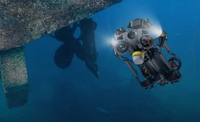
Underwater Drone Survey and Recovery
The integration of underwater drones equipped with hyperspectral cameras represents a groundbreaking advancement in search and rescue operations and surveillance activities. These sophisticated drones are specifically designed to operate in challenging aquatic environments, providing enhanced visibility and detection capabilities far beyond traditional underwater equipment.
Key Features
Hyperspectral Imaging
The core of this technology lies in its ability to capture data across multiple wavelengths of light. This allows for real-time analysis of underwater conditions, helping to identify objects, vegetation, and even submerged hazards that are otherwise invisible to the naked eye.Real-time Data Transmission
Equipped with advanced communication systems, these drones can transmit data back to operators immediately, enabling rapid assessments and informed decision-making during critical missions.Sonar capabilities
These drones are built with sophisticated navigation and obstacle avoidance systems, using sonar to conduct operations in complex underwater terrains, from rivers to oceans.Long Endurance and Depth Capability Designed for extended tethered missions, they can operate at considerable depths, providing comprehensive coverage for search and rescue teams.
Applications
Search and Rescue
In emergency situations, time is critical. The ability to deploy an underwater drone quickly can mean the difference between life and death. With hyperspectral imaging, rescuers can locate missing persons with greater accuracy and efficiency, even in murky waters.Surveillance
For security applications, these drones can monitor aquatic environments for suspicious activity, illegal dumping, or environmental hazards. Their advanced imaging capabilities allow for detailed inspections while minimising the risk to human operators.Environmental Monitoring
Beyond immediate rescue operations, these drones can also be employed for ecological assessments, tracking changes in marine habitats, and responding to environmental disasters.Conclusion
The incorporation of underwater drones with hyperspectral technology into search and rescue and surveillance operations not only enhances effectiveness but also increases safety for personnel. As technology continues to evolve, these drones will play an increasingly vital role in safeguarding lives and preserving Australia’s natural aquatic resources. -
![]()
Animal Identification, Track and Trace with Infrared Technologies
In the field of wildlife conservation and agricultural monitoring, accurate animal identification and tracking are crucial. With advancements in infrared technologies, we can enhance our capabilities in observing, identifying, and tracking various species in their natural habitats or managed environments.
Infrared Technologies in Animal Identification
Infrared imaging offers a unique advantage by capturing data that is not visible to the naked eye. This technology is particularly effective during low-light conditions or at night when many animals are most active. By utilizing drones equipped with infrared cameras, we can monitor animal movements, behaviors, and populations without disturbing their natural environment.Benefits of Using Infrared Technologies
Non-Intrusive Monitoring: Infrared technology allows for the observation of animals from a distance, reducing stress on wildlife and maintaining a natural behavioral baseline.
Enhanced Detection Capabilities: Heat signatures captured through infrared imaging can help in identifying animals that blend into their surroundings, making it easier to locate elusive or endangered species.
Data-Driven Insights: The data gathered through infrared monitoring can be analyzed to provide insights into animal movements, migration patterns, and habitat usage. This information is vital for effective wildlife management and conservation programs.
Track and Trace Applications
The integration of infrared technologies extends beyond identification to tracking and tracing animal movements. By combining infrared imaging with advanced tracking algorithms and GPS data, we can create a comprehensive system for monitoring wildlife.Migration Patterns: Understanding seasonal movements and migration can inform conservation strategies and habitat management.
Population Studies: Accurate tracking aids in determining population sizes and dynamics, allowing for better resource allocation and protection measures.
Land Use Monitoring: Tracking animals' interactions with their environment can identify potential threats such as habitat loss or human-wildlife conflicts, enabling proactive management solutions.
Conclusion
The application of infrared technologies in animal identification and tracking represents a significant leap in wildlife monitoring. By leveraging these advanced tools, we can enhance our understanding of ecosystems and improve conservation efforts, ensuring the protection of various species for generations to come.